


Hurricane Irma winds down, Jose on its tail
September 13, 2017
Early Monday morning, Hurricane Irma weakened to a Category 1 storm, but not before causing significant damage that has resulted in at least 61 deaths across the Caribbean and the Southeast, according to The Weather Channel. This storm, which was for a time wider than the entire state of Florida, shrunk considerably while moving up the western coast of the Florida panhandle.
The classification of a Category 1 storm means that the storm had maximum wind speeds of at least 74 miles per hour but no more than 95, being the mildest tropical cyclone that is still considered a hurricane. At its height, Irma had recorded wind speeds of 185 mph.
The storm continued moving upward and managed to cause severe flooding along its path while continuing to weaken. Flooding in Charleston, S.C. reached levels just shy of the records from Hurricane Hugo in 1989. Locals lamented the “terrible winds.”
In the wake of Harvey, the evacuation for Irma was one of the largest evacuations in U.S. history. Many Floridians are still away from their homes, some traveling as far north as Wilmington to remain safe. One individual told stories of her friend who stayed up all night to fix a junk van just so he would have a way to leave the state.
But now, Hurricane Jose is approaching, and as the nation prepares to take this third hit, many are curious as to what will come from the storm. While Irma was making its way up the Florida coast, Jose was waiting out at sea, circling around the Atlantic.
The storm is projected to move up along the coast, and while still away from the shoreline, it will most likely pass North Carolina Monday morning, at which point it is expected to have downgraded to a tropical storm with wind speeds under 73 miles per hour.
North Carolina will likely not be directly hit by this storm, but at this point, much is still unsure.
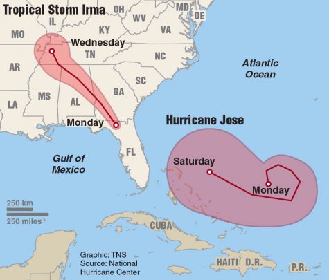
Map of Tropical Storm Irma and Hurricane Jose. Courtesy of Tribune News Service.